
King’s Landing Kuleana Settlement Plan and Environmental Assessment
KING’S LANDING KULEANA SETTLEMENT PLAN AND ENVIRONMENTAL ASSESSMENT
1. current information and announcements (May 2024)
The King’s Landing Kuleana Homestead Settlement Plan Draft Environmental Assessment is Available for Review and Comment
The Settlement Plan DEA can be accessed here:
Figure 1: King’s Landing Kuleana Homestead Settlement Plan

When and How to Submit Comments?
The 30-day public comment period will be open from June 8, 2024 to July 8, 2024. Please submit your written comments, Attention to: Kawika McKeague, before the July 8, 2024 deadline. Submit your comments through any of the following means:
- Email: [email protected]
- Mail: G70, 111 So. King Street, Suite 170, Honolulu, HI 96813
- Fax: (808) 523-5874
Beneficiary Consultation Meeting:
To assist in your review of the King’s Landing Kuleana Settlement Plan Draft EA, DHHL will conduct an in-person Beneficiary Consultation Meeting (see postcard invitation below):
What? Beneficiary Consultation Meeting #2
Why? The purpose of the meeting is to present the King’s Landing Kuleana Homestead Settlement Plan Draft Environmental Assessment (DEA); to answer questions; and to receive oral or written comments on the draft EA.
Who? Invitation postcards for the meeting were mailed to all DHHL beneficiaries residing in Hilo. Other beneficiaries are welcome to attend.
When? WEDNESDAY, JUNE 12, 2024, from 6:30 p.m. to 8:00 p.m.
Where? Keaukaha Elementary School.


About this Webpage
This webpage documents the planning process through the completion of the King’s Landing beneficiaries to develop the King’s Landing Kuleana Homestead Settlement Plan Final Environmental Assessment. The webpage is organized into three (3) sections:
- Section 1 Current Information and Announcements (Date posted): (above) current meeting invitation, documents related to the meeting, and any announcements.
- Section 2 Background Information: (below) maps that depict the planning area, information on: the community association, the Kuleana Homestead Program, and the Kuleana Homestead Settlement Plan Environmental Assessment.
- Section 3 The Planning Process: relevant documents for all planning meetings, consultations, and HHC presentations.
As the Settlement Plan EA is being developed, the webpage will be used to disseminate information and facilitate MAHA/beneficiary input in the planning process. After the Settlement Plan EA is completed, the webpage will be used as a library or archive of information.
2. Background Information
A. The Planning Area
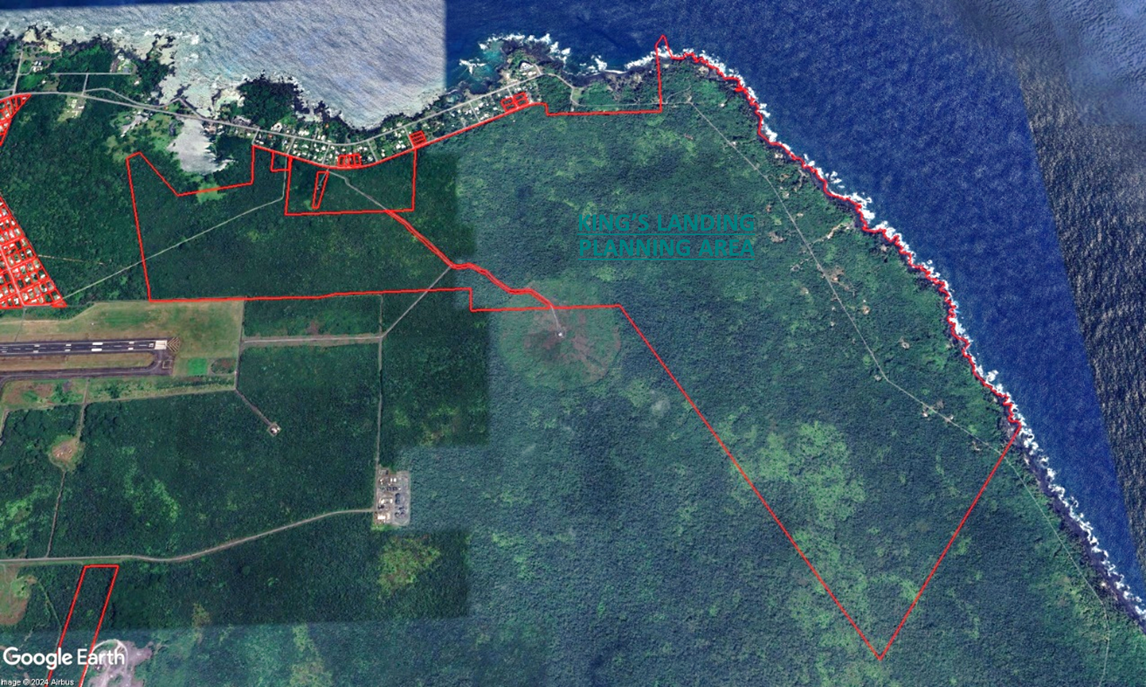
The Hawaiian Homes Commission Act of 1921 set aside 2,000 acres, more or less, in Waiākea-Kai, which is the area we know as Keaukaha. The Keaukaha lands were divided into 2 tracts. Keaukaha Tract I includes approximately 485 Residential Homestead Lots that occupy approximately 295 acres. Keaukaha Tract II, also known as “King’s Landing,” includes approximately 1,323 acres of land that starts mauka of Lokowaka Pond and continues to the border of Hilo and Puna in the ahupua‘a of Waiākea, in the moku of Hilo on Hawai‘i Island (see Figure 2).
Figure 2: Keaukaha Tract I and II

Access to King’s Landing is through Kalaniana‘ole Street which turns into the Kapoho Coast Road at Lehia Beach Park. At Leleiwi Point, which is at the mid-point of the parcel, the King’s Landing tract expands makai to include all the land from the shoreline inland (mauka) about 4,000 feet. Starting at Lehia Beach Park, the Kapoho Coast Road is a rugged dirt road that runs parallel to the coastline providing 4-wheel-drive vehicular access to the eastern border of the property which is the Hilo-Puna District boundary (see Figure 3).
Figure 3: King’s Landing (Keaukaha Tract II) Planning Area
B. MĀLAMA KA ‘ĀINA, HANA KA ‘ĀINA—THE COMMUNITY ASSOCIATION AT KING’S LANDING
Mālama ka ʻĀina, Hana ka ʻĀina (MAHA), is the community/homestead association established by the native Hawaiian beneficiaries who were settling at King’s Landing in the early 1980’s. MAHA is a 501I(3) tax-exempt nonprofit organization that is governed by an elected Board of Directors. Board members must be full-time residents at King’s Landing for at least 2 years.
Membership
Full-time residents at King’s Landing are eligible to be members of MAHA if they are:
- At least 21 years old
- Native Hawaiian (confirmed by acceptance of the applicant’s application by the DHHL)
- An applicant on a DHHL Wait list.
Prospective members must apply and be accepted by the Board of Directors. Upon acceptance, the prospective member is a probationary member, until they meet minimum performance requirements relative to building a safe and habitable residence. More specifically, within 12 months, the probationary member must construct an outhouse at least 10-feet from any residence. In addition, within 12 months, the probationary member must complete the flooring of the structure. Upon satisfactory performance of these conditions, the Board may act to grant regular membership status.
MAHA Membership is significant because members are covered under any permit, license or lease that may be issued by the HHC to MAHA for the use and occupancy of King’s Landing. In this way, MAHA members have been allowed to use and occupy King’s Landing since 1986. While this arrangement provides members with legal access and use of land at King’s Landing, it is not a homestead lease. Right-of-Entry permits are temporary and short-term and the beneficiaries at King’s Landing want a homestead lease that has successorship rights.
Permitted Use and Presence at King’s Landing
Beginning in 1984, the HHC authorized the Chairman to issue a Right-of-Entry (ROE) permit to MAHA which allowed MAHA and its members, “permitted use and presence” at King’s Landing, as an alternative lifestyle settlement, until a management plan for King’s Landing is completed and accepted. Since 1984, the short-term ROE permits would be extended or if conditions and terms were changed, a new ROE would be issued.
Involvement in Developing the Kuleana Settlement Plan
The Administrative Rules related to the Kuleana Homestead Program state that the Department must develop a Kuleana Homestead Settlement Plan for the Tract of land. Furthermore, in developing the Kuleana Settlement Plan, the Rules state that DHHL must work with applicants who are interested in a Kuleana Homestead lease for the Tract of land. Since MAHA is comprised of native Hawaiian beneficiaries who reside at King’s Landing, who know the lands and resources at King’s Landing, and who are interested in a Kuleana Homestead lease at King’s Landing, the Department worked with MAHA to create the King’s Landing Kuleana Homestead Settlement Plan.
 C. The Kuleana Homestead Program
The Kuleana Homestead Program was initiated by beneficiaries to provide a homestead alternative for those who are unable to participate in DHHL’s conventional residential homesteading program because they cannot qualify for a 30-year home loan or prefer to not incur the debt of a home loan. The original concept of the Kuleana Homestead Program was envisioned by Keli‘I “Skippy” Ioane, a pioneer at King’s Landing. The concept was refined by MAHA members as they developed their Community Management Plan for Subsistence Homesteads at King’s Landing in 1987. In 1992, the Kuleana Homestead concept was developed further by a group of native Hawaiian beneficiaries on the island of Maui as they developed a Conceptual Plan for Kahikinui. In 1998, Administrative Rules (HAR §10-3-30) for the Kuleana Homestead Program was officially adopted as a homestead lease alternative. In 1999, DHHL awarded Kuleana Homestead Leases to 75 applicants on the Maui Pastoral Waitlist for Kuleana homestead lots in Kahikinui, Maui.
The Kuleana Homestead Program allows beneficiary applicants to settle on the land faster than conventional leases by awarding vacant, unimproved lands, “as is.” Lessees agree to participate in community work days and road maintenance. The lessees are responsible for providing their own utilities, such as electrical, water, wastewater disposal, and communications.
For many years, beneficiaries have expressed a strong desire to pursue alternative settlement options and to have a role in helping to manage and preserve the natural and cultural resources of a given homestead area. Beneficiaries also requested for the Department to deliver homestead lots at a quicker rate by awarding raw, undeveloped land. A short summary of how the Kuleana Homestead Program came to be:
D. THE KING’S LANDING KULEANA SETTLEMENT PLAN
The Administrative Rules for the Kuleana Homestead Program require DHHL to work with interested applicants to develop a Kuleana Settlement Plan. The Rules specify that the Settlement Plan should include:
- The location and description of the tract;
- The approximate size and number of lots to be awarded;
- The approximate location of a community center and common areas;
- Preliminary conceptual proposals for community management and economic development of adjacent department lands, if applicable;
- A plan for the identification, protection and preservation of all significant historical, archaeological, and biological sites; and
- The settlement timetable to commence after the award of the lots.
3. THE PLANNING PROCESS AND PLANNING DOCUMENTS
The table below provides an outline of the planning meetings, beneficiary consultations, and HHC presentations that were conducted in the process of developing the Settlement Plan Environmental Assessment.
| 1 | Background Materials | |
| 2 | MAHA Planning Sessions |
|
| 3 | Beneficiary Consultation Meetings |
Tuesday, October 24, 2023, 6 p.m. – 7:30 p.m. Keaukaha Elementary School Presentation Meeting Notes (no link yet)
Wednesday, June 12, 2024, 6:00 p.m. – 8: Presentation to be posted later (no link yet)
|
| 4 | Hawaiian Homes Commission Presentations |
Item G-3– DHHL King’s Landing Kuleana Homestead Settlement Plan
Presentation (no link yet) |
| 5 | Kuleana Settlement Plan Environmental Assessment |
|
