
EARLY NOTICE AND PUBLIC REVIEW OF A PROPOSED ACTIVITY IN A WETLAND AND FLOODPLAIN
SUBJECT: EARLY NOTICE AND PUBLIC REVIEW OF A PROPOSED ACTIVITY IN A WETLAND AND FLOODPLAIN, DEPARTMENT OF HAWAIIAN HOME LANDS, ANAHOLA KULEANA HOMESTEAD SETTLEMENT PROJECT, ANAHOLA AND KAMALOMALO‘O, ISLAND OF KAUAI TMKs: 4-4-8-002:001 (por.), 003:006 (por.), 4-4-7-002:004 (por.), (REF: 2025-0075499)
To: All interested Agencies, Groups and Individuals:
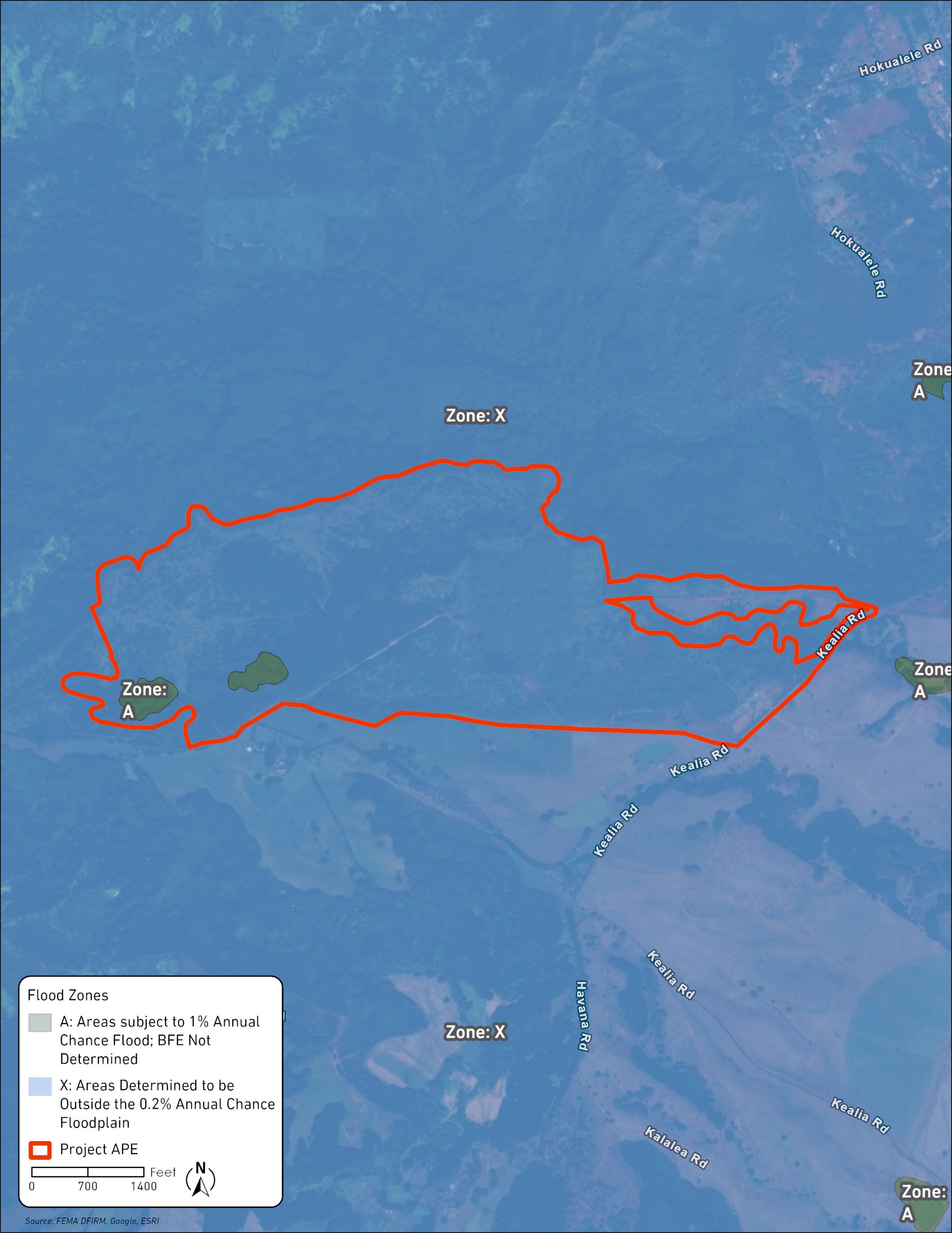
This is to give notice that the Department of Hawaiian Home Lands (DHHL), the Responsible Entity under 24 CFR Part 58, has determined that the following proposed action under the State of Hawai‘i, DHHL Anahola Kuleana Homestead Settlement Project 23HBGHI0001 NH-24-17.07 is located a Federal Flood Risk Management Standard (FFRMS) floodplain and wetland, and DHHL will be identifying and evaluating practicable alternatives to locating the action within the floodplain and wetland and the potential impacts on the floodplain and wetland from the proposed action, as required by Executive Order 11988, as amended by Executive Order 13690 and Executive Order 11990, in accordance with HUD regulations at 24 CFR 55.20 in Subpart C Procedures for Making Determinations on Floodplain Management and Protection of Wetlands. The proposed project is located midway between Līhu‘e (14 miles south) and Hanalei (18 miles north), and just north of the residential/resort towns of Kapa‘a and Wailua. The extent of the FFRMS floodplain was determined using the 0.2 percent flood approach, and the project is in Federal Emergency Management Agency (FEMA) Flood Zone X (481.86 acres), areas determined to be outside the 0.2% annual chance floodplain, and FEMA Flood Zone A (10.76 acres), areas with a 1% annual chance of flooding.
The Anahola Kuleana Homestead Settlement project proposes the construction of residential units of up to 115 homestead lots (14 Pastoral lots and 101 Subsistence Agriculture lots) as well as services such as homeowner assistance, which may include assistance with down payment and closing costs, mortgage, utilities and insurance payments, rental and utility assistance, and housing counseling utilizing HUD funds. For the purposes of this review, residential construction includes infrastructure for water, wastewater, communication, and energy within the homestead parcels as well as drainage, grubbing, grading, and trenching within the homestead parcels as necessary to prepare for residential unit construction and to ensure adequate drainage of the lot.
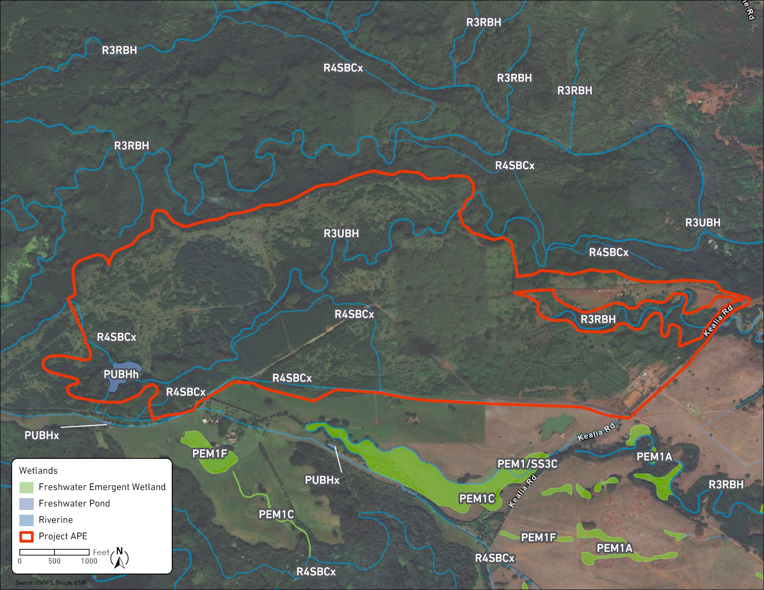
The project is located on an approximately 493-acre portion of Tax Map Key(s) (4) 4-8-002:001 (por.), (4) 4-8-003:006 (por.), (4) 4-7-002:004 (por.)–the project area. DHHL is the Responsible Entity undertaking the project and is the owner of the project area. The project area includes parts of the interrupted Ka‘alūlā Stream, Kaneha Ditch, Reservoir Number 2, and Reservoir 3. Reservoir 2 is approximately 5.5-acres in size, Reservoir 3 is approximately 5.6-acres in size, and the streams and ditches within the project area total approximately 4 miles. The areas of Reservoir 2 and Reservoir 3 generally correspond to the FEMA Flood Zone A designation; all other project areas are designated FEMA Flood Zone X. According to the National Wetlands Inventory Wetlands Mapper, Reservoir 2 is classified as freshwater pond habitat, and the stream and ditches within the project area are classified as riverine habitat.
The project area was previously used for plantation agriculture, which used the reservoirs, streams, and ditches for crop irrigation. The Hawai‘i Department of Health, Clean Water Branch classifies the waters located within the project area as “Class 2” waters. Class 2 waters are those that should be protected for recreational purposes, the support and propagation of aquatic life, agricultural and industrial water supplies, shipping, and navigation. Currently, reservoirs 2 and 3 are essentially dry and only fill during periods of heavy rainfall. Ka‘alūlā Stream is an interrupted stream, perennial but with segments sometimes dry, that runs through both reservoirs and through the project area.
From November 5 to 7, 2018, a biological survey was conducted on a 467-acre portion of the project area including a portion of Ka‘alūlā Stream. No federally threatened or endangered species were observed in the waterways of the survey area. Two endemic species were observed, the slender Kaua‘i damselfly (Megalagrion oresitrophum) and the endemic goby, o‘opu nākea (Awous stamineus). The biological survey also tested Ka‘alūlā Stream water quality and found turbidity and total suspended solids increased with distance downstream.
In 2018, an Archaeological Reconnaissance Survey (ARS) was conducted on 467-acres within the project area and characterized the reservoirs and ditches as water distribution and storage from as early as 1904. In 2020, a Cultural Impact Assessment (CIA) was conducted on 462-acres within the project area and found that access to resources, effects of the project on water resources downstream, and the stewardship of gulches within the project area that feed into streams are areas of concern. In 2024, a site visit was conducted for the project area and, along with the ARS and CIA, established that:
- Continued use through the decades, into modern times, has compromised significance and integrity of the plantation hydrological system and its features, with the exception of a concrete irrigation-ditch feature bearing inscriptions from its builders.
- The upslope large reservoir(s) that defined and fed the plantation water systems in the study area have been decommissioned or are in active stages of decommissioning.
Currently, the Project is consulting with the State Historic Preservation Office (SHPO) for compliance with state historic preservation requirements and is anticipating a determination of no archaeological historic properties within the project area. DHHL is also currently consulting with SHPO as a part of the Section 106 process, as ground disturbance is anticipated in the footprint of the existing roadway and ditch system to horizontal and vertical extents that are presently indeterminate pending design plan finalization and/or confirmation. SHPO requested DHHL conduct a Reconnaissance Level Survey (RLS) of the existing agricultural site features that were previously identified as a part of the Chapter 6E process to assess the distribution and significance of these sites as architectural historic properties.
The initial draft RLS conducted by Fung Architecture (FAI) in October 2025 noted the sites were once a part of developed agriculture lands, particularly used for sugar cane and pineapple cultivation. When commercial agriculture operations ended, these lands we left unmanaged. Currently the sites are located in thick shrubs, forested areas, and areas with roaming wild cattle. Nature has taken its course in naturally reclaiming these lands. For properties to be considered eligible for inclusion on the National Register of Historic Places, they must possess historic significance and integrity. To evaluate the integrity of a property, an important aspect is understanding that a property evolves over time. The expectation that a property retains all of its physical features or characteristics from its historic time period is improbable. However, a property must maintain the essential characteristics in order to convey its significance.
The RLS indicated that portions of the Site #1 ditch and Site #5 reservoir retain some aspects of integrity as significant historic properties. The other Sites evaluated from the ARS were not considered individually eligible. These sites retain little to no aspects of integrity as a historic property and some sites lack historic significance. Furthermore, the research conducted did not find a potential grouping of related significant properties which share themes, trends, and patterns. The eight sites’ setting, feeling, and association have been compromised by the presence of thick, overgrown non-historic vegetation. Important physical attributes and features that would comprise integrity of the specific sites and their historic connection to each other are not apparent due to heavy non-historic vegetation. Potential attributes and features have presumably either been obliterated or hidden due to immense vegetative overgrowth, or they have been removed and are no longer extant. There is no clear continuity to each other and their agricultural history. DHHL’s master plan will avoid adverse impacts to any significant historic sites identified in the ARS and the RLS.
There are three primary purposes for this notice. First, people who may be affected by activities in the floodplain and wetland and those who have an interest in the protection of the natural environment should be given an opportunity to express their concerns and provide information about these areas. Commenters are encouraged to offer alternative sites outside of the floodplain and wetland, alternative methods to serve the same Project purpose, and methods to minimize and mitigate Project impacts on the floodplain and wetland. Second, an adequate public notice program can be an important public educational tool. The dissemination of information and request for public comment about the floodplain and wetland areas can facilitate and enhance Federal efforts to reduce the risks and impacts associated with the occupancy and modification of these special areas. Third, as a matter of fairness, when the Federal government determines it will participate in actions taking place in the floodplain and/or wetlands, it must inform those who may be put at greater or continued risk.
Written comments must be received by DHHL at the Office of the Chairperson, Attn: Malia Cox Via their consultant, G70 at [email protected] or to the DHHL by mail at 91-5420 Kapolei Parkway, Kapolei, HI 96707 attn Malia Cox before December 12, 2025.
Mahalo,
Kali Watson
Chairperson
Hawaiian Homes Commission